Solutions
Signalling
ETCS and CBTC projects present design and interoperability challenges from legacy datasets and diverse railway control systems. Our services provide critical support in addressing these challenges.
Design Challenges
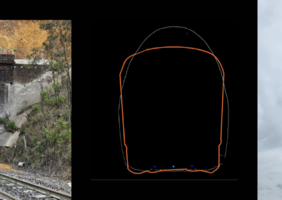
Modern train control systems require detailed information on the rail corridor. Traditional surveying methods are time-consuming and legacy datasets can contain inaccuracies.
Interoperability Challenges
Ensuring seamless communication and compatibility between different railway networks is crucial for safe and effective rail operations.
Our team develops tailored geospatial solutions to meet your project needs:
Precision Mapping
Our MLS surveys capture high-resolution 3D data, providing detailed models of the rail corridor to streamline design and integration with existing infrastructure.
Data Consolidation
We address outdated and inconsistent legacy data, improving accuracy and reliability.
Automated Data Extraction
We generate reference data on existing corridor assets in formats that can be easily ingested by design software.
Standardised Data Exports
We export data in formats compatible with multiple train control systems.
Featured Services
Why Work With Us?
Expertise
Our team of rail and geospatial professionals understands the unique challenges and requirements of signalling and train control projects.
Innovation
We leverage the latest advancements in LiDAR technology to provide solutions that meet the demands of modern signalling projects.
Commitment
We are dedicated to delivering high-quality, reliable geospatial information that supports successful ETCS and CBTC initiatives.
Contact Our Experts Today
Related Projects
Downer Group Leaky Feeder
ARTC ATMS