Xerra
Rail Corridor Analytics
Improve productivity with indexed LiDAR and imagery
What can XERRA do?
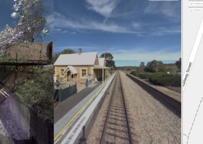
XERRA allows users to undertake virtual visits anywhere in the rail corridor.
XERRA supports maintenance, asset management, design and construction projects.

Asset Resilience
Understand asset condition within a 3D point cloud. Plan changes and secure funding for upgrades and replacements.
Maintenance Digital Twin
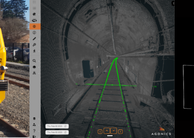
Automate measurements and check sighting distances, while reducing time spent in the danger zone.
Design
Accelerate designs with accurate, quality assured data that describe the network as is rather than rely on outdated information.
Dilapidation
Secure a record of the physical environment pre and post construction with feature-rich 3D rail corridor visualisation.
Constructability
Optimise construction efficiency and staging within a 3D environment.
Asset Validation
Validate your asset inventory while preserving legacy asset information critical for digital systems.
Compliance Reporting
Compliance benefits with XERRA
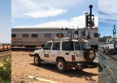
All LiDAR data is indexed to your track to support comprehensive reporting.
Improve safety outcomes
By not sending workers into the danger zone you immediately reduce one of the biggest risks facing your organisation.
Optimise resources
Automating measurements from LiDAR reduces the volume of manual measurements in the field.
Dilapidation and Completions
Meet contractual obligations for dilapidation surveys and data requirements for completions.
Constructability
Optimise construction efficiency and staging within a 3D environment.
")
Keen to know more? Book a demo today
XERRA Features
![]()
Upload your own data
![]()
Uses industry standard LiDAR
![]()
View and interact with LiDAR
![]()
Search LiDAR on the map
![]()
Generate cross-sectional views
![]()
Take measurements
![]()
Export profiles
![]()
Share links with others
![]()
Secure cloud storage
![]()
Load your trajectory data
![]()
Load vehicle outlines
XERRA Projects
Sydney Trains MIDT
UGL Regional Linx Survey
ARTC MLS Interstate Network
Discuss your project with us
XERRA in numbers
Designed for rail professionals, XERRA is the industry’s most trusted platform for visualising high-resolution LiDAR and imagery datasets of the rail corridor.
Certified track LiDAR
Active users
Assets validated
Client Testimonials
Don’t take our word for it – here’s what our clients say:
“XERRA is an excellent supplementary tool for engineering design and construction planning. It helps fill the gaps that are left by traditional physical survey, site photography and inspection records. If you are working on a remote project with limited physical survey, or where project design and construction teams are limited in their ability to visit the sites, you need to be using XERRA.”
![]()
Mario Vlasich
McConnell Dowell
“We chose to work with Agonics due to their team’s deep experience in working at scale across rail networks, their proven Mobile Laser Scanning (MLS) and visualisation technologies, and expertise in converting complex rail engineering requirements into working solutions.”
![]()
Based on the successful completion of the
Interstate Asset Capture Project
“XERRA is a powerful, user-friendly visualisation tool. It’s obvious that it has been developed by people who have an in-depth understanding of the nuances of the railways.”
![]()
Engineer – Major Works
Sydney Trains
![]()