MAY 2022
We often get asked by our clients whether the datasets we collect can be used to perform assessments of sighting distances at level crossings. To answer this question, we decided to do some investigations of our own into this important area of rail and road user safety.
What we did
Our investigations have shown that level crossing approach sighting distances can be measured from track LiDAR data using the Agonics XERRA software. Several level crossings along the ARTC Interstate Network were selected as a demonstration dataset whereby road vehicle stop positions and level crossing protection assets were classified in the LiDAR point cloud (point cloud themed to monochrome).
Then, using a simulated train driver vantage point at various approach distances from the level crossing we were able to observe where the level crossing was obscured from the driver’s line of sight.

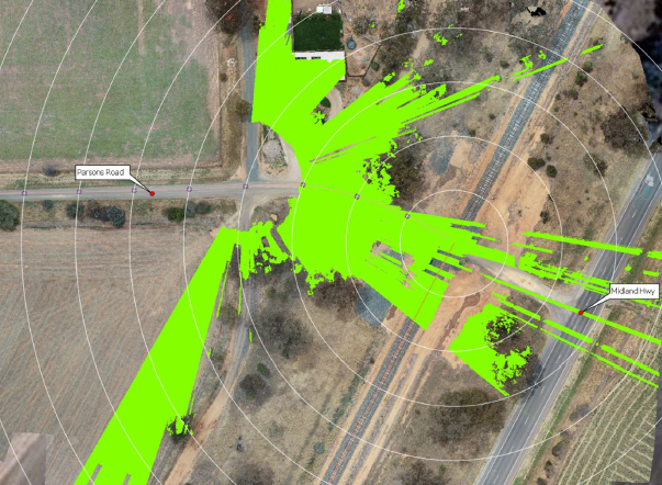
We have also recorded drone imagery over several rural Victorian level crossings so that the location at which a car driver first observes the train can be estimated. Our track LiDAR data generally has a swath width of 50-100m but LX protection in the form of signage and rumble strips is generally further away from the crossing.
The orthophotography generated from the drone allows us to project sightlines from the car’s position to the track and where obstructions are present the line of sight is truncated resulting in a radar-style plot of sightline limits.